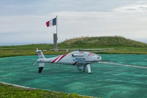
 The European Maritime Safety Agency (EMSA) contracted Schiebel to support multi-purpose maritime operations with its Unmanned Air System (UAS) CAMCOPTER S-100 in La Manche and the southern section of the North Sea. The operation aimed to assist the maritime authorities of Belgium and France across a variety of coast guard functions including emission monitoring. Stationed […]
Schiebel CAMCOPTER S-100 Supports European Coastguard Functions in France and Belgium
 The European Maritime Safety Agency (EMSA) contracted Schiebel to support multi-purpose maritime operations with its Unmanned Air System (UAS) CAMCOPTER S-100 in La Manche and the southern section of the North Sea. The operation aimed to assist the maritime authorities of Belgium and France across a variety of coast guard functions including emission monitoring. Stationed […]


