It’s Time! Commercial UAV Expo Call for Speakers The organizers of Commercial UAV Expo recently released their call for speakers, accepting new submissions until March 7th. According to their press release, their Call for Speakers invites industry leaders, innovators, and experts to apply to present case studies and experiences around the theme, Drones in Action: […]
At this year’s Drone Show Korea (DSK) 2025 in Busan, a notable keynote highlighted the potential of drone technology in transforming medical logistics, particularly in developing countries. Dr. Yi Zhang, a Health Economist at the World Bank, presented compelling research on how drones could bridge critical healthcare gaps. Challenges in Healthcare Logistics Developing countries face […]
New System Meets Unique Maritime Security Challenges with Advanced Technology D-Fend Solutions, recognized for its radio frequency (RF) cyber-based, non-kinetic, non-jamming, counter-drone takeover technology, today unveiled the EnforceAir2 Maritime. This latest iteration of their EnforceAir2 system is specifically designed to cater to the unique demands of maritime and naval environments. Specialized Design for Maritime Use […]
Mark your calendars for Tuesday, March 4, at 3:00 PM EST and join the next installment of the Public Safety Drone Review. This episode will focus on how drones are revolutionizing public safety operations and the best ways to manage the risks involved. We’re excited to have Amy Wiegand, an expert in drone business development, […]
Next up in our “Ask Drone Girl” series is a multi-part question about GIS courses, getting a job in mapping and DJI’s future in the U.S. If you have a question for Drone Girl, contact her here.
I’m a city planner with 18 years of experience and a background in GIS (though it’s been a while since I used it heavily). I recently purchased a refurbished DJI Mini 3 to learn to fly without breaking the bank if I dunk it in water. My goal is to move into drone work as a private contractor or employee, and I plan to get my Part 107 this summer. I have a few questions:
Is there an online GIS, drone mapping, or photogrammetry program you’d recommend?
Is there really enough work in the U.S. for all the registered commercial drone pilots? I feel like I’m late to the game.
Given the looming U.S. ban on DJI, should I invest in a commercial/enterprise DJI product, or would that be a bad move? Alternatives seem expensive, and I’m also considering working in Europe. Do American drone companies release SDKs for off-brand mapping software?
I love a good multi-part question! SO much to work with here! For starters, I’m glad you’ve started with a drone that’s affordable. I always recommend new pilots start with a cheap, toy drone that they can afford to lose. A refurbished yet still high-quality drone is the way to go!
Okay, moving on to each part of your question:
1. The best GIS courses specific to drones and photogrammetry
Since you already have a GIS background, you’re in a great position to get into drone mapping. I’ve already put a pretty extensive guide to the best drone mapping courses. Of course, the best course for you might be a bit different based on your existing experience. You’ll likely want to go with a program that relies on a software you already have or are familiar with.
Though, here’s a quick tl;dr of some drone mapping and GIS courses you might want to look into.
Best online mapping course: Pilot Institute’s Drone Mapping, Modeling & Surveying Bundle
Price: $299 Time to complete: ~10 hours What you’ll learn:
Drone mapping fundamentals
How to create models with Bentley ContextCapture and Pix4D
Processing images into high-quality maps using DroneDeploy, Metashape, and Pix4D
This course is great for someone who wants a broad overview rather than a deep dive into a single software. Since you’re already somewhat familiar with GIS, this might be a great way to brush up on concepts and get hands-on with drone-specific software.
Price: $1,999 (includes lunch!) Locations: Major U.S. cities (Atlanta, Chicago, Denver, Houston, etc.) Check out the list of upcoming workshops here. What you’ll learn:
RTK & PPK concepts (important for high-precision mapping)
Hands-on drone mapping exercises
Processing RTK/PPK data using Pix4D Mapper and Emlid Studio
Networking with drone professionals
Yes, it’s pricey, but if you prefer hands-on learning, the real-time feedback can be invaluable. This course also includes free access to UAV Coach’s online mapping course ($199 value).
2. Is it too late to start a drone career?
Absolutely not. If anything, now is the perfect time to enroll in one of those GIS courses and land a great job in drones.
Not getting into drones now is like skipping out on investing at the top of a bull market in January 2020. Investing all your savings in the stock market in January 2020 would have felt like a mistake if it’s March 2020. But if you wouldn’t have touched that money otherwise, then today it’s still a brilliant move. Of course, investing in March 2020 would have been better in hindsight, but it’s impossible to time the market. Either way, investments made in either of those months are worth a lot more today.
That’s how it is getting into drones. You might have had way more opportunities to get into the field in 2013 (that’s when I started this website!). But what will you say 10 years from now?
Don’t wait for the perfect time to get in, or wish you had enrolled in one of those GIS courses in earlier. Just start now! That’s because drone industry growth is accelerating, not slowing down. According to the Global Drone Industry Review 2024 from Drone Industry Insights, global commercial drone flight hours hit 10.8 million in 2024, which is already a 29% increase from 2023. A plurality of those drone flight hours are happening in Asia, which leads with 3.8 million flight hours, followed by Europe and North America. Of course, drones generally aren’t flying for more than an hour. So if you count by total takeoffs versus hours, total commercial flights reached an estimated 19.5 million in 2024, according to DII.
As far as where the work actually is, most drone businesses are small teams. Should you want to pivot to a career in drones, know that 55% of drone companies have fewer than 10 employees, according to DII’s Global Drone Review. Luckily for you, most commercial drone pilots work in niche industries (mapping, inspections, agriculture, etc.), which means expertise—like GIS skills—go a long way.
If you’re worried about competition, don’t be. The biggest opportunities are in specialized fields like mapping and surveying. That GIS experience of yours? That’s your golden ticket.
3. Should you invest in a DJI enterprise drone?
Drone makers are leaning into enterprise drones, such as DJI’s Mavic 3 Enterprise, to hedge against the hobby drone market shrinking.
Is it still wise to buy DJI drones amidst proposed DJI drone bans? This is where things get a little hairier. I definitely do not have a crystal ball. If I did, I would have taken way more advantage of investing in the stock market in March 2020!
I also can’t tell you about what will happen to potential bans on Chinese drones in the U.S. going forward. There’s no outright ban yet, but there is plenty of proposed legislation to ban DJI drones including the Drones First Responders Act.
If you’re trying to land a gig via a government contract, know that many of those federal gigs in the U.S. do not allow you to use DJI drones. Some private clients also don’t hire contractors who use DJI drones given data security concerns.
That said, you may still want to consider DJI drones. Mid-level mapping drones like the Mavic 3 Enterprise offer the best price-to-performance ratio on the market. Meanwhile, DJI’s software ecosystem is the most mature. Many third-party mapping applications like DroneDeploy and Pix4D are optimized for DJI drones.
That said, if you’re focused on landing U.S. drone mapping gigs, it could be wise to invest in either an American-made drone, or one that is made abroad but from a company trusted by the U.S. government. Brace yourself for a far higher price than similar DJI products, but your options include the Freefly Astro Prime drone, the Parrot Anafi USA drone and the Sony Airpeak S1.
Price: $299 (Use coupon code DRONEGIRL100 to save $100!) Time to complete: 15-20 hours What you get:
350+ FAA practice questions
17-page cram sheet (WAY better than longer e-books)
Unlimited 1:1 support with a Part 107 success coach
Weekly live Zoom instruction options
Pass guarantee: If you fail after passing a practice test, they cover your $175 test fee
Why I love it: I (Sally, The Drone Girl!) personally used Drone Pilot Ground School as my only study resource—and I passed on my first try. Their materials are clear, concise and continuously updated for FAA rule changes.
Best to pair with your online mapping course: Pilot Institute
Price:$249 Time to complete: 15-20 hours What you get:
Lifetime access
20 quizzes + 15 hours of video lectures
Money-back pass guarantee
Why consider it? If you’re enrolling in their online mapping course, then it can make sense to stay in the same Pilot Institute ecosystem. Plus, it’s a tad cheaper than Drone Pilot Ground School, assuming no coupons.
Of course, you can take one of those courses in tandem with the GIS courses, or break them apart. A drone pilot’s Part 107 license is valid for two years but it can be easily renewed online for free.
– Boeing has hired an adviser to sell its defense subsidiary Insitu, a maker of small, long-range military drones, Bloomberg News reported, citing people familiar with the matter. The aviation giant seeks to shed non-core assets and focus on its commercial and defense businesses. Insitu is drawing interest from private equity firms and corporate buyers, […]
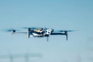
U.S. drone manufacturer Skydio has been awarded a contract by Spain’s Ministry of Defence (MINISDEF) to supply autonomous small uncrewed aerial systems (sUAS) technology to the Spanish Armed Forces. In partnership with Paukner Group, a Spanish defense and security product distributor, Skydio will deliver Skydio X10D drones in a contract worth up to €18 million ($18.7M […]
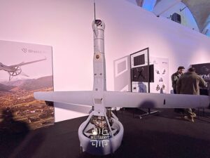
The American drone manufacturer Shield AI is looking for partners in Ukraine among manufacturers of laser-guided munitions to equip its V-BAT drone. James Lithgow, director of Shield AI, told Militarnyi about this at the Defense Tech Innovation Forum 2025 exhibition. “The drone can carry a combat payload, and it is already working in the United […]
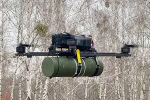
The Ukrainian Ministry of Defense has codified and approved for operation in units of the Defense Forces of Ukraine unmanned aerial systems U13 and U15 of Ukrainian production. This was reported by the Main Directorate for Lifecycle Support of Armaments and Military Equipment. The drones of these complexes are designed to destroy protected firing positions, […]

 Gstaad – Diablerets, Switzerland
 Captured from the skies, this stunning drone footage showcases the majestic beauty of Glacier 3000 like never before!
 Perfect for travel vlogs, documentaries, or your next creative project.