Acquisition Expands Delair’s Reach in Defense and Civil Markets, Leveraging Grenoble’s Technological Hub to Compete Globally in Robotics and Industrial Drone Solution by DRONELIFE Staff Writer Ian J. McNabb French drone developer Delair recently announced the acquisition of Grenoble-based swarm drone developer SQUADRONE SYSTEM. SQUADRONE serves both the military market, through the TAMOS (Tactical Multi-Objectives […]
Industry Faces Regulatory and Security Hurdles, but FAA Collaboration Sparks Hope The AUVSI New England UAS and AAM Summit kicked off with a powerful morning keynote from AUVSI President and CEO Michael Robbins. Against the backdrop of the conference theme, “If We Build It, Will They Come?” Robbins addressed the state of the drone industry, […]
Get Z is seemingly the tech generation. They do school on zoom, they shop on TikTok, and they’ve never known life without iPhones. However, they are not actually the generation most eager for a future filled with drone grocery delivery
That honor goes to Millennials, which is the generation most likely to use drone delivery to deliver groceries. That’s according to the “Beyond the Aisle: The 2024 State of Grocery Shopping and Delivery.” Wing, which is a massive drone delivery company affiliated with Google, generated the report based on survey data from 5,000 American adults. Wing conducted the drone grocery delivery survey in July 2024, which consisted of 17 multiple-choice questions about grocery shopping and delivery habits.
Graphic courtesy of Wing
According to the survey, 68% of millennials said that they’re likely to use drone delivery for small grocery orders. That’s in acknowledgement of the statement that drone delivery can help provide speed and convenience.
That’s above the survey average, open which 58% of all respondents said they would likely or very likely use a drone delivery service if it were available.
Why Gen Z isn’t that interested in drone grocery delivery
Now here’s where it gets really interesting. Just 57% of Gen Z said they’re likely to use drone delivery for small grocery orders. Now, that doesn’t necessarily have to be concerning. Drone delivery is a new tech, and the companies behind it surely hope it’s here to stay. That might mean that getting Gen Z onboard now is critical. After all, Gen Z has the longest life ahead as a potential customer.
However, it’s critical to note that Gen Z didn’t say they were opposed to drone delivery. It’s more that they don’t anticipate using it now. Drone delivery can be expensive. Gen Z is a generation largely of people in college or just out of college who doesn’t have the money to spend on conveniences.
Susie Sensmeier (right) and Paul Sensmeier (left). Photo courtesy of Wing.
And speaking of convenience, drone delivery has shown enormous benefit in the oldest generations who are less mobile. An older person might have more trouble driving or walking to a grocery store to pick up food for the next few days (or to grab a takeout meal). They might find the trek to the pharmacy to pick up a prescription to be onerous. Just ask 84-year-old Susie Sensmeier. She’s one of Wing’s top customers. Unable to drive given weakened vision, she says she found drone delivery to be far more convenient than navigating a physical retail store (let alone getting there).
In contrast, a Gen Z customer might not find running errands to be all that cumbersome. They might even live in a city, where stopping in a market to grab last-minute groceries isn’t difficult anyway.
How Americans shop for groceries today versus what they actually want
Wing’s drone delivery tests with Walmart in particular have sought to upend grocery delivery. You order through the Walmart app. Online shopping is a growing trend, drone or not. Online grocery sales are expect to account for 19% of e-commerce orders by 2020, according to a separate report from Insider Intelligence. Additionally, Wing’s survey found that about half of American’s get once-a-week grocery delivery,
When you use Wing’s delivery service through Walmart, you can order all sorts of small groceries, like butter, pasta sauce, 6-packs of eggs and individual beverages.
The key there, though is small. I tested a Wing drone delivery for myself out of a Walmart store in Fort Worth, Texas, and was fascinated to see that the drone could delivery a 6-pack of eggs, but not a 12-pack. Presumably, the box designed specifically to mount on the Wing drone is too narrow for a 12-pack carton. Similarly, a 12-pack of drinks would be too heavy. But, it can deliver one-off drinks.
A Wing representatives told me that limes were one of the most popular drone delivery orders. Presumably people making margaritas forgot a key ingredient, just as the party was getting started. And hey, drone delivery does double up as a cool party trick.
Speaking of getting limes now for the party that’s starting, well, now: that aligns with a top priority among customers. The survey found that speed is critical when it comes to the power of grocery deliveries. 84% of survey respondents said that, when online shopping, they expect grocery orders to arrive within the same day. What’s more, a smaller yet more demanding cohort, 30% of shoppers, said they wanted grocery deliveries to arrive within the hour.
Small items only: is that a bad thing?
Don’t expect drone delivery partnerships with Costco anytime soon. At present, Wing drones can only make deliveries weighing up to about 2.5 pounds. That means orders are limited to mostly small, single items.
However, there might be enough of a use case. Wing calls them “Boomerang trips.” These are trips where shoppers have to return to the store for a key ingredient they forgot. That’s something like the lime described above. And according to the survey, 62% of shoppers say they make such “Boomerang trips.”
Will Americans pay for speedy drone deliveries?
Currently, the online shopping process isn’t typically as fast as just going to the store yourself. In fact, the Wing survey found that 60% of consumers say they choose to shop in-store because it’s faster than waiting for a delivery driver.
With drones, that’ll likely change. And good news for investors wondering if drone delivery is financially viable, customers have indicated it could be. 76% of the survey respondents said they’d pay for ultra-fast delivery of their order, meaning that it arrives within 30 minutes or fewer. But going back to the Gen Z question mark, here’s where it gets interesting. An above-average amount — 83% of Gen Zs — said they would be willing to pay more for ultra-fast delivery.
And here is good news for investors looking for a long-term payoff in drone delivery: Gen Z does in general have a greater willingness to pay for delivery. Here’s the percentage of shoppers who said they were willing to pay for delivery, according to Wing’s grocery survey.
18-24 year-olds: 83%
25-34 year-olds: 82%
35-44 year-olds: 83%
45-54 year-olds: 78%
54+: 59%
Graphic courtesy of Wing
Of course, plenty of people will not pay for drone deliveries — or deliveries of anytime. Grocery delivery can add about 10% to a bill. And according to the survey, 50% of survey respondents said they preferred doing their own in-store shopping or pickup purely to avoid having to pay delivery fees and associated costs, such as tips.
A bright future for drone delivery
My first drone delivery experience was positively delightful, and many Americans say they want to undergo a similar experience. The survey asked people who said they never use standard deliveries if they would be open to drone deliveries. Of those folk, 44% said yes, they’d like to do a drone delivery.
And of those who have already tried drone delivery, most like it. 65% of shoppers said that drone delivery improved the overall experience.
The U.S. Marines are testing a system for standard service rifles that automatically fine-tunes the point of aim with the help of a powered buttstock as a new option to help shoot down drones. The service is in the midst of a broad push to acquire new capabilities to help every Marine better protect themselves from ever-growing uncrewed […]
In response to the escalating need for advanced counterdrone technologies across Europe, DroneShield an innovator in counter-unmanned aerial systems (C-UAS), has announced the expansion of its European footprint. To enhance its regional capabilities, DroneShield has strategically appointed a team of seasoned C-UAS professionals, establishing a strong presence in both Denmark and Germany, complementing and supporting its existing strong European […]
– Aerodata AG has announced that it has been granted a Supplemental Type Certificate (STC) by the European Union Aviation Safety Agency (EASA) for its advanced GPS Anti-Jamming and Anti-Spoofing solution. This certification applies to installations integrated with Garmin 5000 avionics in a Cessna Citation Latitude jet. With the growing threat of GPS jamming and […]
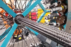
A study by composites manufacturer Quickstep Technologies and RMIT University has concluded that braiding technology offers an opportunity to enhance the production rate of composite structures for eVTOL UAS applications. A collaboration between Quickstep, RMIT and the Defence Science Institute studied the use of advanced composite manufacturing methodology — braiding — to produce the primary […]
– DELAIR has announced the acquisition of Grenoble-based drone manufacturer SQUADRONE SYSTEM, a specialist in drone swarms and industrial inspection. The Toulouse drone manufacturer confirms its dual development strategy (civil & defense) and accelerates the deployment of its technological roadmap. Founded in 2014 in Grenoble, SQUADRONE SYSTEM., with a workforce of 22 and estimated turnover […]
Join us on Tuesday, November 5, at 3:00 PM EST for the latest episode of the Public Safety Drone Review. This month’s discussion will explore the challenges law enforcement faces when communities report unauthorized drones or drone-related crimes. The event will feature DJ Smith, a covert surveillance and counter UAS expert, who currently serves as […]
Key Stakeholders Outline the Path Forward for UAS and AAM Networks At the AUVSI New England UAS and AAM Summit held today in Cambridge, MA, industry leaders gathered to address a pressing question: “If We Build It, Will They Come?” The panel discussion, titled “Infrastructure Supporting Advanced Aviation Operations,” brought together experts to explore the […]