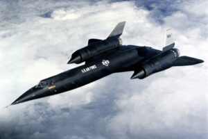
The Lockheed A-12 is a retired high-altitude, Mach 3+ reconnaissance aircraft built for the United States Central Intelligence Agency (CIA) by Lockheed’s Skunk Works, based on the designs of Clarence “Kelly” Johnson. The aircraft was designated A-12, the 12th in a series of internal design efforts for “Archangel”, the aircraft’s internal code name. In 1959, […]
DJI Modify Enhances Workflow Efficiency in Surveying, Transportation, and Emergency Response with Interoperability and Smart Editing Capabilities by DRONELIFE Staff Writer Ian J. McNab DJI recently announced their new model editing software, DJI Modify, which is designed to integrate seamlessly with their range of enterprise drones and 3D modelling and mapping software, DJI Terra. The […]
Virginia-based Drone Delivery and Drone Services Firm Enhances Healthcare Logistics with Latest FAA Approval by DRONELIFE Staff Writer Ian J. McNabb Virginia-based autonomous drone developer DroneUp recently announced that they had received approval from the FAA to conduct BVLOS drone deliveries. This approval will allow DroneUp to commence operations at Riverside Health System installations while […]
CISA Issues Guidance on Mitigating Risks Posed by Chinese UAS, AUVSI Advocates for a Secure Domestic Drone Industry In a recent publication, the Cybersecurity and Infrastructure Security Agency (CISA) has reiterated concerns about the risks posed by Chinese-manufactured unmanned aircraft systems (UAS) to critical infrastructure and U.S. national security. The guidance, jointly released with the […]
Largest FAA Waiver of Its Kind Enables Groundbreaking Drone Operations Over 377 Square Miles, Paving the Way for Future National Drone Management Solutions By DRONELIFE Staff Writer Ian J. McNabb The Choctaw Nation of Oklahoma BEYOND program recently announced that it had received an expanded beyond visual line of sight (BVLOS) use authorization from the […]
DJI Terra has proven to be the drone maker’s easy-to-use mapping software, automating the steps for which a drone can capture imagery needed to generate 2D and 3D maps. But while it’s pretty good at making maps, there’s not a lot in the way of being able to clean up and further process the models generated. That might change today with the launch of DJI Modify.
DJI Modify is a new piece of intelligent 3D model editing software designed to work with DJI Terra. In a nutshell, it takes your existing 3D models, and it makes the steps to repair little defects in them far more efficient than it had been.
Image courtesy of DJI.
How DJI Modify works with DJI Terra
Consider DJI Modify to be the new jelly to the peanut butter that is DJI Terra.
DJI Terra is the company’s photogrammetry-based 3D model reconstruction software. Using DJI LiDAR for 2D and 3D reconstruction of visible light, the software is then able to process that data to build a 2D or 3D model.
Up until now though, the process of editing those models has been cumbersome. Most users have defaulted to third party applications such as Autodesk RecapPro or MapTiler to do so.
But now, you won’t need to leave the DJI ecosystem to edit files.
DJI Modify allows you to import and export model files in common formats including ply, obj and b3dm. That makes them compatible for use with DJI Terra, as well as other third-party software.
Once in DJI Modify, you’ll primarily see intelligent auto-repair features. These can help with all sorts of functions such as flattening, editing textures, repairing water surfaces, removing floating parts, and filling holes.
On the simple end, there’s the option for one-click repairs. If you want to get more granular, you might manually make changes by selecting custom polygons, areas, or meshes.
What’s nice is that you’ll see the changes made in not just the high-quality models, but in those low-quality models too. That means you can edit quickly with minimal loading time.
A screenshot shows how 3D models can be edited in DJI Modify. Image courtesy of DJI.
Who is DJI Modify for?
DJI Terra has become a popular software for people using drones for aerial surveying, modeling, and model editing. That encompasses a range of use cases, including surveying, transportation, and emergency response such as firefighting.
Anyone currently using DJI Terra should consider augmenting their software collection with DJI Modify.
Flaws with DJI Modify
That said, the software has its drawbacks. Annoyingly, you’ll need to use separate software to share your processed model files to the cloud. That said, DJI says it already has an update in the works so that processed models can be shared to the cloud for online viewing and sharing via links without software installation.
It’s also not for people on an ultra-tight budget. For starters, a one-device download of DJI Terra Pro Permanent costs $4,400. (Luckily, there are more affordable options. For example, the 1-year subscription version of DJI Terra Agriculture covers 3 devices and costs just $300).
But if you want DJI Modify, it’s another $1,580. While that might be a drop in the bucket for the big corporations using drones, that might be hard to justify for a small business or individual entrepreneur launching a drone mapping business.
A screenshot shows how 3D models can be edited in DJI Modify. Image courtesy of DJI.
DJI Terra (with DJI Modify) vs other drone mapping software
While it’s hard to make completely direct comparisons, other slightly similar drone mapping software might fit your needs at a lower price. For example, Autodesk ReCap Pro costs $380 for an annual subscription. You might even find that Autdodesk ReCap Pro’s $50 monthly subscription is all you need. Autodesk ReCap Pro is particularly well-suited for 3D models.
MapTiler is better for 2d orthomosaic maps, but it’s also an excellent deal. In fact, it’s got a $0 version (though features on the free one are super limited). Even still, its flex plan that targets startups is just $50 per month.
Of course price can be a dealbreaker, but for many users, quality is even more so a dealbreaker. When it comes to quality, DJI Terra seems to be tops.
For example, one user on the DroneDeploy forum posted the same images using DJI Terra vs. DroneDeploy (which is a Terra competitor). DJI Terra’s output is noticeably better, with sharper surfaces, accurate edges and higher resolution.
Image courtesy of DJI.
A history of DJI Terra
DJI Terra first launched in 1019 in response to the need for a more streamlined drone mapping solution. It’s well suited for use cases such as public safety, construction, infrastructure, or agriculture. That’s because it doesn’t necessarily require tons of mapping expertise — but it can provide visualized data that experts in those fields might use.
Terra software integrates with all of the latest DJI drones. That removes barriers around switching platforms and transferring files to multiple formats to upload data. And data processing times themselves are efficient, largely thanks to the simple drag and drop workflow.
And while data security has been a hot-button in the drone world — particularly when it comes to DJI drones — here’s a compelling point: assuming you’re in offline mode, DJI Terra does not require an Internet connection (if you’re fine foregoing the cloud-based aspect).
What’s your go-to drone mapping and editing software? Will you give DJI Modify a try? Leave your comments below!
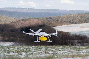
For residents of the Michelstadt districts served as part of Wingcopter’s LieferMichel pilot project, the year begins with two good news at once: They can continue to have smaller errands delivered conveniently and with zero emissions by delivery drone and cargo bike. In addition, the range will be expanded to include non-prescription medicines. The extension […]
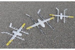
Alphabet’s Wing unveiled the first in a new lineup of larger drones with more payload capacity. The new drone can handle up to five pounds without sacrificing range and has enough battery power to complete 12 miles round trip while cruising at up to 65 mph. Adam Woodworth, CEO, made the announcement on the company’s […]
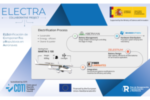
Within the framework of the 2023 Aeronautical Technology Programme, Embention, Fiber Laminates, Zelestium and Abervian, leaders in different aspects of aircraft and electrification, have joined forces on the ELECTRA project. A cutting-edge initiative addressing the electrification of the Martin 3 S100, a dual seat aircraft with 600 Kg MTOW. ELECTRA’s main objective is the development […]
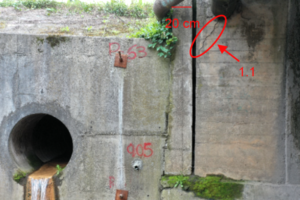
In research funded by the Vice-Rector’s Office for Research and Doctorates of the Universidad San Sebastián, Chile, various image processing techniques were examined to detect cracks and fissures in bridges, using UAV as a tool to perform a visual inspection inventory. The technology used met expectations by reaching hard-to-reach areas where cracks are common. Additionally, […]

 The Lockheed A-12 is a retired high-altitude, Mach 3+ reconnaissance aircraft built for the United States Central Intelligence Agency (CIA) by Lockheed’s Skunk Works, based on the designs of Clarence “Kelly” Johnson. The aircraft was designated A-12, the 12th in a series of internal design efforts for “Archangel”, the aircraft’s internal code name. In 1959, […]