Archer Aviation Partners with NASA to Advance Air Mobility Archer Aviation Inc. (NYSE: ACHR), a leading innovator in electric vertical takeoff and landing (eVTOL) aircraft, announced today a significant partnership with the National Aeronautics and Space Administration (NASA). The collaboration, established under the NASA Space Act Agreement, aims to ensure U.S. leadership in the next […]
Partnership Paves the Way for Enhanced UAS Services and Drone Detection Networks Across the United States In a strategic move aimed at enhancing drone delivery and other advanced drone applications, DeFli Networks, a decentralized drone detection and UTM solutions network, has entered into a partnership with Walmart in the United States. This collaboration will involve […]
Making a panoramic photo with your drone is one of the best ways to take what’s already a soaring scene and make it even more immersive. Though they can be tricky to make yourself, software like Adobe Photoshop, Panovolo and even DJI’s own apps can make generating a drone panorama a headache-free experience.
Panoramic photos are those ultra-wide shots that can sometimes even appear as a 360-view of the landscape. And while there are some cameras designed to specifically take panoramas such as the Insta360One, it’s more likely that panoramas are “manually” made. In the case of making a panoramic photo with a drone, a series of photographs are combined or “stitched” together to generate a single, wide panoramic image.
In fact, some drones have built-in software programs that allow them to automatically generate panoramas. But even if you have a drone with built-in panoramic software, using it might not be the best move.
Manually making a panoramic image — as described by the steps in this guide using special tools — can often provide even more details thanks to using multiple large images. That means digital views can zoom in ultra–tight, or quality is better if printing. The tools described below also tend to allow for more control over the photo’s composition (as opposed to leaving it up to the automated tool on your drone).
Your ultimate guide to making panoramic images with drones:
Have the right gear — including a great camera drone
The DJI Mavic 3 Pro and Cine are two of the best drones for making aerial https://amzn.to/3V9TKqOpanoramas. Photo courtesy of DJI.
It goes without saying that — in order to make a high-quality panoramic image — you’ll also need a high-quality camera drone. Check out my guide to the best camera drones.
If you’d rather save a click, my recommendations are:
Each of the above options from DJI come with automatic panorama shooting modes that you can select from when connected to your DJI smartphone or tablet app. Just note that there are a few limitations, particularly on the recommendations that have multiple cameras. For example, the medium tele-camera on drones such as the DJI Air 3 and Mavic 3 Pro do not support Panorama. In those situations, you’d need to use other software on your computer to stitch and generate panoramic photos (we’ll share those software options below).
Use DJI’s built-in panoramic software (the easiest option)
Annoyingly, the Autel Evo Lite+ does not offer automatic panoramas in-app (which might add on to the reasons why DJI is absolutely dominant in the consumer drone space).
Delightfully, DJI does. You can find DJI’s panoramic software within your drone’s app, which is designed to be intuitive to use. Simply navigate to the Panorama portion of the app. From there, you can select from a view unique panorama shooting options that produce various effects, which typically include Sphere, Wide Angle, and 180° panoramas.
For example, Wide on the DJI Mini 2 SE produces more of a fish-eye effect, seen in this sample image provided by DJI:
Meanwhile, 180° ends up to be an overall wider shot with less image distortion. See DJI’s provided image below to compare the 180° vs Wide panorama shooting mode:
There are downfalls to using DJI’s in-house panoramic photo tool. Not all DJI drones are compatible, and as mentioned above, some cameras on otherwise-compatible drones may not be.
Of course, you obviously can’t go this route if you’ve got a non-DJI drone. And sometimes you just want to have more control than what DJI allows. With skill, a manually-edited panoramic image will turn out far superior.
So with that, here are your next option for making a panoramic photo with your drone:
Take photos manually with your drone and edit them separately
Who needs DJI’s automatic panorama software when you can do it the old-fashioned way?
You can take a series of photos with your drone, and then stitch them using software tools later on. There are some tips to follow when going this route:
Ensure your photos overlap sufficiently: Ultimately you’ll be stitching your photos together, which means you’ll need sufficiently overlap so you have enough wiggle room to ensure they align. In general, try to take enough images so that they overlap by approximately 40%.
In total, expect to have taken between 20-30 images for a smooth panorama.
Keep the image style consistent: Generally speaking, stick to the same camera settings when shooting all the photos that will comprise your single panoramic photo.
That means sticking to one focal length if you have a zoom lens, while not changing other settings such as aperture (assuming your camera allows for an adjustable aperture) or exposure.
Keep your images level: With ground photography, the recommendation is to shoot all your images using a tripod with a rotating head to ensure the camera height is consistent throughout.
With drone photography, making panoramas is arguably easier, especially since today’s drones have simple-to-use features like altitude lock that will maintain the drone’s position. You simply yaw right or left to see the full scene all around you.
Once you’ve got your images, it’s time to turn to editing software to put them together into one glorious panorama. Here are my recommendations for the best drone panorama software:
The Photomerge tool in Adobe Photoshop
Adobe Photoshop is considered the top-of-the-line when it comes to photo editing software. It’s the most advanced and allows for the most autonomy so you can modify your photos exactly how you want.
Within Photoshop is a tool called Photomerge, which combines several photographs into one continuous, panoramic image. It’s super easy to use. Simply select File > Automate > Photomerge.
From there, you’ll select the image files you intend to use and you’ll be directed to choose a few custom settings including the layout option, whether distortion should be corrected and whether vignettes should be removed.
The biggest drawback here? Photoshop is expensive. It’s sold on a subscription basis, with an annual subscription usually going for $264 per year. If you’re frequently making drone videos too, you might consider going all-in and purchasing Adobe Creative Cloud. Creative Cloud unlocks the entire collection of Adobe creative software such as Premiere Pro, which is a must-have for video editing, and other artistic tools such as Illustrator and InDesign.
Panovolo
A screenshot of the Panovolo software.
For software that’s tailored specifically for drone panorama image stitching (and a lot cheaper than Photoshop), consider Panovolo. At just $29.99 for the year, it’s a bargain compared to Photoshop’s $264 price tag.
This relatively-new software launched in December 2023. With it comes state-of-the-art image analysis thanks to the company’s optimization algorithms that uses the position and orientation information saved by the drone.
The final product? A geometrically accurate panoramic image.
The software offers multiple customization options and accommodates both DNG (RAW) and JPEG images. Once it’s ingested your image, select from a wide array of panorama types, including spherical and cylindrical. There’s even the stereographic style, which you might recognize via those “small planet” images.
And it doesn’t stop once your panoramic photo is made. From there, Panovolo makes it easy to share to social media or integrate with maps. For example, you can pinpoint the exact locations where images were captured on a 3D map.
It’s available on macOS 12 (Monterey) or newer, as well as Windows 10 or 11, 64-bit. Download Panovolo here.
Other tips for making a panoramic photo with a drone
Shoot in RAW format: This gives you more flexibility for adjustments in post-processing.
Use a neutral density filter (ND filter): ND filters are a must-have drone accessory to control exposure in bright conditions, preventing blown-out highlights. Learn more about how ND filters can improve drone photography.
Practice! The more you fly and experiment, the better your panoramas will become.
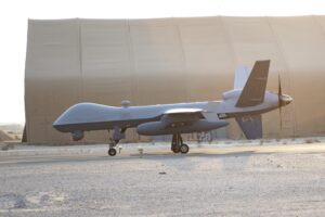
An American MQ-9 Reaper drone crashed in northern Iraq on Jan. 18, as the U.S. continues to fend off attacks from Iran-backed militias, U.S. officials told Air & Space Forces Magazine. The U.S. Air Force MQ-9 was likely downed by an Iranian-provided surface-to-air missile fired by an Iranian-affiliated Iraqi group, U.S. officials said. The MQ-9 was supporting […]
Kaman Corp. announced that it has entered into a definitive agreement to be acquired by Arcline Investment Management, L.P., a growth-oriented private equity firm with deep experience investing in technology-driven, meaningful-to-the-world industrial businesses, in an all-cash transaction with a total enterprise value of approximately $1.8 billion. Upon completion of the transaction, Kaman will become a […]
A laser weapon which could be fitted to future generations of Royal Navy warships has successfully destroyed aerial drones for the first time. A burst of a high-intensity beam from Dragonfire costs no more than £10 – yet can bring down incoming drones, missiles and aircraft. After nearly a decade in development and an investment […]
A Chinese company reportedly knocked off an Iranian military drone, no less, and listed it for sale on Alibaba online marketplace. The drone is similar to the one from the Shahed series and was listed without the payload, before being yanked off the site, the report said. According to X user Byron Wan, a company […]
YellowScan, a global designer of the next generation of manned and unmanned LiDAR solutions, announced the release of its new bathymetric system, the YellowScan Navigator, at the world’s most powerful tech event – CES 2024. We have all witnessed the impact of climate change: drier and warmer seasons, interspersed by heavy rains and flooding rivers. […]
We tell you all about the most beautiful drone spots in the main French cities that our members had the opportunity to film!
Here is the city of Lyon in this article with aerial images from Grenoble Drone Vision, our drone pilot based near the city.
In this article, the objective is to discover the best spots to film Lyon by drone. From Croix-Rousse and Vieux-Lyon in Fourvière, passing through the modern district of Part-Dieu without forget Confluence, each place offers a unique view from the air. The article will conclude with advice for finding a drone videographer professional in this emblematic city.
Enjoy your reading & your drone flights !
—————————
On continue notre série sur les plus beaux points de vue drone dans les principales villes françaises que nos membres ont eut l’occasion de filmer!
Voici notre article sur Lyon avec les images de notre correspondant sur Lyon, Grenoble Drone Vision.
Dans cet article, l’objectif est de faire découvrir les meilleurs spots pour filmer Lyon par drone. De la Croix-Rousse et du Vieux-Lyon à Fourvière, en passant par le quartier moderne de Part-Dieu sans oublier Confluence, chaque lieu offre une vue unique depuis les airs. L’article se conclura avec des conseils pour trouver un droniste vidéaste professionnel dans cette ville emblématique.
In this article, the objective is to discover the best spots to film Lyon by drone. From Croix-Rousse and Vieux-Lyon in Fourvière, passing through the modern district of Part-Dieu without forget Confluence, each place offers a unique view from the air. The article will conclude with advice for finding a drone videographer professional in this emblematic city.