Collaboration to Establish Standards and Certification Program for UGV Cybersecurity Neya Systems, a leading provider of off-road autonomy and mission planning software, has announced a new partnership with the Association for Uncrewed Vehicle Systems International (AUVSI) to create a cybersecurity and supply chain framework and certification program for uncrewed ground vehicles (UGVs). This initiative aims […]
Skyfront MagniPhy Enhances Surveying, Mineral Prospecting, and UXO Detection Skyfront, a leader in high-endurance hybrid drones, has launched the Skyfront MagniPhy, its latest drone magnetometer solution. This new tool is designed for various applications, including surveying, mineral prospecting, detecting orphaned wellheads, and finding landmines and unexploded ordnance (UXO). The Skyfront MagniPhy features a new enclosure […]
Ever wanted to see world’s largest tree — by drone, no less? Some drone pilots took to photographing the massive, natural wonder for quite a practical reason.
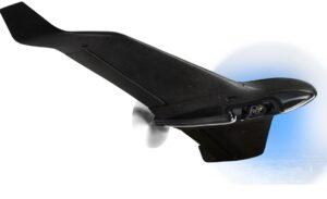
The tree, dubbed General Sherman, sits within California’s Sequoia National Park. And in May 2024, the U.S. National Park Service — in a partnership with groups including the Giant Sequoia Lands Coalition — commissioned a drone flight to conduct a first-of-its-kind health check-up for the tree.
General Sherman stands 275 feet tall and more than an estimated 2,200 years old.
With that project, an Freefly Astro Prime drone flew over the canopy. Across its flights, the drone carried a range of different sensors such as a lidar payload to detect changes in the canopy.
The health check-up comes at a critical time for research of the beloved giant sequoias. An estimated 20% of the world’s giant sequoias have been lost in the last four years alone. That’s due in large part to California’s wildfires. But that’s not all. A species of beetle has also been invading the trees, causing entire trees to die.
This drone inspection had a fairly happy ending. While researchers used the drone data to detect some degree of native bark beetle activity, researchers concluded that it wasn’t a concerning amount.
“Drones give us an ability to scale out those observations,” said Sam Prentice, a soil scientist and drone specialist with the Forest Service.
Check it out here:
How to monitor forest health via drone
No, this project was not as simple as just flying a cheap camera drone over a tree to check it out. After all, those beetles are tiny, and their impacts often aren’t even seen with the naked eye. Given that, a more advanced drone carrying a payload smarter than a basic camera came into the picture.
Drone used: For this project, pilots used Freefly’s Astro Prime drone. The Astro Prime is a relatively new version of the original workhorse commercial UAS platform from Freefly. The Astro Prime is NDAA-compliant and Blue UAS-approved.
Payloads used: The drone was mounted with various swappable payloads, including a Lidar scanner and HD video camera.
Communication system used: From there, the drone called on mesh rider radios from Doodle Labs. The mesh rider radios establish a resilient datalink, maintain connectivity and full control of the drone in an off-grid environment. That enables them to reliably send high-bandwidth data back to the ground.
If you’re planning to map a forest within a National Park, know that you’ll need approval. Drone use is typically banned in National Parks under 36 CFR 1.5. That rule prohibits launching, landing, or operating drones on lands and waters administered by the National Park Service (NPS) NPS.
To conduct aerial mapping missions, researchers need to obtain special permits from the NPS. You can usually check with the park superintendent to see if an area can be designated within the park. They’ll outline how to get a special use permit if necessary.
Violation of the ban is a misdemeanor with the maximum penalty of six months in jail and a $5,000 fine.
What this project signals for use of drones in environmental science
“The capabilities of the Astro prime and its NDAA-compliant status will enable the U.S. Forest Service and other Department of Interior groups to call on the platform for continued use in land mapping and inspection much faster than older manual processes,” according to a statement from Doodle Labs.
It’s also compelling to see the particular choice by the U.S. Forest Service to use a Freefly drone. Freefly is an American drone company. Its products are designed, assembled, tested, and supported by the Freefly team at its headquarters in Woodinville, Washington. Freefly products are also far more expensive than a DJI drone. The Freefly Astro Prime Drone with a Sony ILX-LR1 camera costs a hefty $27,000.
But the U.S. government’s decision to utilize the American-made Freefly drones for aerial mapping can be seen as a signal of growing interest in supporting domestic drone manufacturers like Freefly over their Chinese counterparts, DJI. Recently, politicians have raised concerns regarding potential security risks associated with Chinese-made drones. While Freefly drones may not possess the same widespread brand recognition as DJI, this project signifies a potential shift.
AgEagle Aerial Systems Inc., a provider of best-in-class full stack flight hardware, sensors and software for commercial and government use, has announced that the Company has secured a purchase order to deliver 20 eBee VISION full-stack systems with control systems, batteries, backpacks, and limited spares, to a leading distributor in the United Arab Emirates (UAE). […]
The German Ministry of Defence announced at Eurosatory 2024 that Denmark, Germany, and Hungary signed a letter of intent in Paris for the joint procurement of SKYRANGER as part of the European Sky Shield Initiative ESSI. The turret system can be integrated into Boxer vehicles, for example. It is considered the cornerstone of the German […]
BAE Systems is launching its next-generation 40mm anti-aircraft system, Tridon Mk2, at Eurosatory 2024, showcasing its unique capability to protect against ever-evolving aerial threats. “The Tridon Mk2 is the ideal solution for combat operations, where soldiers need a proven, high-precision and reliable anti-aircraft system to keep the skies clear and protect troops and infrastructure,” said […]
AeroVironment Inc., Simi Valley, California, is awarded a $13,691,731 cost-plus-fixed-fee order (N6833524F0079) against a previously issued basic ordering agreement (N6833519G0059). This order provides for the development of automated entity classification in video using soft biometrics, in support of advanced image and video analytics capabilities for unmanned system technologies, including the optimization of system design through […]
At Eurosatory 2024, Safran Electronics & Defense has announced the launch of its Skyjacker counter-drone solution. Skyjacker is an effective response to the growing threat posed by drones in the battlespace and at sensitive installations. Skyjacker’s strength lies in its unique spoofing capability: it alters the trajectory of a drone to neutralize the threat it […]
Low SWAP-C UAS Payload to Enhance Replicator Initiative MatrixSpace has been awarded a $1.25 million Direct-to-Phase II SBIR contract by AFWERX to develop a low SWaP-C (Size, Weight, Power, and Cost) multi-function, multi-band antenna payload. This new project, based on the MatrixSpace Radar hardware platform, aims to address key challenges within the Department of the […]
Recent Contracts with French Army and UAE Signal AgEagle’s Strategic Shift and Rapid Expansion Potential by DRONELIFE Features Editor Jim Magil AgEagle Aerial Systems, a company that started about 14 years ago as a manufacturer of drones and related products for the agricultural sector, is poised to see explosive growth based largely on sales of products […]