
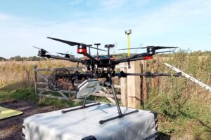
 Experts at Cranfield University are leading a two-year project which combines Synthetic Aperture Radar with uncrewed aerial vehicles (UAV). Synthetic Aperture Radar (SAR) uses radio waves to make detailed images of the Earth’s surface. It bounces waves off objects, measures their return time, and combines the data to create a high-resolution map. The project, led […]
Radar Drones Could Revolutionise Flood and Drought Management
Experts at Cranfield University are leading a two-year project which combines Synthetic Aperture Radar with uncrewed aerial vehicles (UAV). Synthetic Aperture Radar (SAR) uses radio waves to make detailed images of the Earth’s surface. It bounces waves off objects, measures their return time, and combines the data to create a high-resolution map. The project, led […]