
This article is a step-by-step tutorial showing how to charge the DJI Mini 4 Pro drone batteries.
Drone Innovation Skyrockets with Open Source Software: A Report from Dronecode Foundation
Open-Source Advancements in Drone Technology: A Report on Dronecode Foundation’s Contributions and Community Growth In the rapidly evolving world of drone technology, the Dronecode Foundation is a center of innovation and collaboration. Through its commitment to open-source software, the foundation is driving advancements in aerial robotics, a term that has become synonymous with drones, reflecting […]
The post Drone Innovation Skyrockets with Open Source Software: A Report from Dronecode Foundation appeared first on DRONELIFE.
LIFT Aircraft Introduces First Pay-Per-Flight eVTOL Experience
Is this the future of personal aviation? LIFT Kicks Off US Tour LIFT Aircraft, a leading innovator in electric vertical takeoff and landing (eVTOL) technology, has announced the launch of the world’s first eVTOL customer flight experiences. This groundbreaking development was unveiled during a historic event, as a live broadcast flight was featured on Good […]
The post LIFT Aircraft Introduces First Pay-Per-Flight eVTOL Experience appeared first on DRONELIFE.
Cypher Robotics Introduces Revolutionary Inventory Cycle Counting Technology at MODEX2024
New Partnerships with GreyOrange and Ericsson to Enhance Warehouse Automation Cypher Robotics unveiled its innovative solution for efficient and accurate inventory cycle counting at MODEX2024, the sector’s leading annual global conference. The company announced its collaboration with AI-driven automation leader GreyOrange, technology giant Ericsson, and a prominent Canadian retailer, marking a significant advancement in warehouse […]
The post Cypher Robotics Introduces Revolutionary Inventory Cycle Counting Technology at MODEX2024 appeared first on DRONELIFE.
The No. 1 reason why businesses don’t use reality capture software
The future of drones might not be just drones — but rather a field called reality capture. Reality capture encompasses not just drones, but other tools like ground robots and 360 cameras. All those tools together have the potential to better capture data autonomously. And though DroneDeploy initial started as a drone mapping software company, it’s increasingly leaning into the broader field of reality capture. But the company also sought to find out: why don’t business use reality capture software?
The San Francisco-based drone mapping and reality capture software company DroneDeploy surveyed 1,447 users from 119 countries across 13 industries in mid-2023 to find out. And it turns out, it mostly comes down to cost.
“Cost is the main barrier to adoption,” according to DroneDeploy’s State of Reality Capture 2024 report. The report also cited uncertainty about how to prove return on investment (ROI) as another big reason — both of which received 30% of responses as to why businesses were not using reality capture software. Another fairly significant contributing factor? 19% of respondents said they didn’t have enough time to research options.
Cost (and it’s cousin, burden to prove ROI) is one thing, but the lack of time to research options is a bit ironic. After all, if time is money — then having reality capture software very well might save businesses time (and thus money).
According to DroneDeploy’s report, 86% of enterprise respondents estimated that in the past 12 months, reality capture has saved their company at least $5,000. A smaller yet still impressive 49% of respondents had saved $50,000 or more. And 25% saw savings of more than $100,000.
Bigger companies unsurprisingly saved more overall money. Almost half (46%) of companies with 100 employees or more had saved between $10,000 and $100,000. But no matter the company size, there seems to be a financial benefit. According to the report, 96% of businesses reported a positive return from their investment in reality capture — meaning only 4% purchased the software but didn’t see an equivalent or greater financial gain.
How much does reality capture software cost?
So how much does reality capture software cost? It varies based on plan features and company that you go with. DroneDeploy, which is the same company that commissioned the survey above, is one of the biggest players in drone mapping software. It’s also pretty transparent about its pricing. Here are DroneDeploy prices as of March 2024:
| Individual Plan (price per month, but billed annually) | Advanced Plan, which offers more advanced flight + analysis (price per month, but billed annually) | |
| Construction sector | $329 | $599 |
| Energy sector | $329 | $599 |
| Agriculture sector | $129 (ag lite plan) | $329 (individual plan) |
| Property management sector | $329 | $599 |
| Other sectors | $329 | $599 |
Note that prices are displayed as per month prices, but DroneDeploy bills annually. So, a $329 plan would cost $3,948 per year, and a $599 plan would cost $7,188 per year. DroneDeploy also offers team rates, enabling your entire company or team access to software. Those prices vary by individual company, so you’ll have to contact them for a quote.
The plans differ in terms of features. For example, with most plans, the individual version gets you just a 3k image upload per map, while the advanced gets you 10k image upload.
Other software can be more affordable though. Pix4D offers one of the cheapest software selections out there. It’s priciest, Pix4D mapper, starts at $292 per month. Pix4D considered one of the leading photogrammetry softwares for professional drone mapping. It’s used to transform aerial images into survey-grade accurate and georeferenced orthomosaics, points clouds, 2D maps, and 3D models for analysis, inspections, and measurements.
Swiss-based Pix4D offers many software options though, and among the most affordable is Pix4Dreact. At just $37.50, it’s a much lighter-weight tool that makes just 2D maps (though that might be sufficient for certain situations).
How to get reality capture software for free or cheap
You don’t have to pay thousands of dollars for DroneDeploy though — at least not yet. All new users start with a 14-day free trial, which you can sign up through their trial page. DroneDeploy also offers discounts for certified non-profits and educational institutions through the DroneDeploy.org spinoff.
Similarly, Pix4D also offers free trials on most of its products.
You might also consider free types of reality capture software. For example, WebODM can be useful for people already familiar with GIS. The local drone mapping software can process drone imagery into maps, models and measurements.
What is reality capture software — and is it worth it?
Reality capture software is a pretty broad term for any sort of software that allows you to combine and export data, and then share that data as 3D virtual models. There’s even a software literally called RealityCapture, and it’s a photogrammetry/3D scanning software application.
Reality capture software relies on all sorts of tools, which can include drones with cameras, or drones with LiDAR — or even ground robots with cameras or LiDAR.
The most popular tools for data capture, according to DroneDeploy (accompanied by % of survey respondents who use those tools), are:
- high-resolution cameras (100%)
- 360 cameras (56%)
- LiDAR / laser scanners (56%)
- RGB or PTZ cameras (50%)
- thermal cameras (42%)
And what are those types of cameras or scanners mounted to? According to the DroneDeploy survey, 96% of respondents put them on drones. It’s perhaps unsurprisingly to see a figure so high, given it’s unlikely a non-drone user would turn to a company with ‘drone’ in its name (though 4% have).
The software is critical to fields including construction, oil and gas and renewable energy. But, it’s even used in fields like video game making.

And as for whether or not it’s worth it, at least users claim it is. DroneDeploy asked its customers to cite the top benefits of using reality capture software. They are:
- better visibility of projects (77%)
- saving time and costs (57%)
- greater customer satisfaction (56%)
- improved communication with teams or stakeholders (50%)
The post The No. 1 reason why businesses don’t use reality capture software appeared first on The Drone Girl.
[NEW VIDEO PRODUCTION] FOR THE BOUCHES-DU-RHÔNE DEPARTMENT
Video shot at the beginning of March 2024, 100% by drone, during the extension and restructuring works at the Collège Gilbert Rastoin in Cassis.
The aim was to film the new steel structure before it was covered.
Only the Mavic 3 Pro was used for the occasion, mainly the 24 and 70mm focal lengths.
Do you have an audiovisual project of your own?
Contact us on 06.4619.49.26 or email us
————————-
Vidéo réalisée début mars 2024, 100% par drone, pendant les travaux d’’extension et de restructuration du Collège Gilbert Rastoin à Cassis.
II s’agissait de filmer la nouvelle charpente métallique avant son recouvrement.
Seul le Mavic 3 Pro a été utilisé pour l’occasion, principalement les focales 24 et 70mm.
 https://youtu.be/NTqmMgEicX8
 Vous avez vous aussi un projet audiovisuel ?
 Contactez nous au 06.4619.49.26 ou via le formulaire
The post [NEW VIDEO PRODUCTION] FOR THE BOUCHES-DU-RHÔNE DEPARTMENT appeared first on DRONESTAG.
Russia Tests FPV Drones on Fiber-Optic Cables in Ukraine
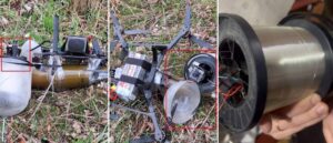 The invasion forces of Russia have started using FPV drones controlled via fiber optic wires. This way of signal exchange makes the UAVs completely invulnerable to any electronic warfare systems as they operate without reliance on radio communication. The emergence of these drones came to light through a report by Serhii ‘Flash‘, an expert at […]
UK to Supply More than 10,000 Drones to Ukraine
 The announcement was made on March 7th by Defence Secretary Grant Shapps as he met President Zelenskyy in Kyiv. Britain steps up support to Ukraine with a complete package of £325 million for cutting-edge drones to help fight Putin’s illegal invasion. The investment, which will deliver more than 10,000 drones for the Ukrainian Armed Forces […]
San Francisco Voters Approve Facial Recognition Drones
 San Francisco voters awarded local police more power and less oversight. A ballot measure that will ostensibly help San Francisco police catch suspects in criminal cases by easing restrictions on vehicle pursuits, allowing for the use of more surveillance technology and reducing oversight from the Police Commission was on its way to passing, according to […]
AVT’s CM234 Gimbal Designed for TUAS Missions
 Incorporating high-quality imagery and four-axis stabilisation in less than 6.6kg, the CM234 from AVT Australia delivers the highest performance of imaging capabilities for the lowest SWaP in its class. The CM234 gimbal combines seven sensor configurations in a compact gyro-stabilised imaging system weighing just under 6.6kg. With four-axis active stabilisation, the CM234 offers greater accuracy […]